×

UPSC Courses

DNA banner

DAILY NEWS ANALYSIS

  • 08 October, 2020

  • 5 Min Read

Playing catch up in flood forecasting technology

Playing catch up in flood forecasting technology

Context:

  • The article analyzes the current flood forecasting system in India and its lacunae and suggests appropriate measures to improve it.

Floods in India:

  • Floods have been a recurrent phenomenon in India and cause huge losses to lives, properties, livelihood systems, infrastructure and public utilities.
  • According to the National Disaster Management Authority, around 40 million hectares of land in India are exposed to floods (around 12 percent of the total land area).
  • The most flood-prone basins are those of the Ganga and Brahmaputra in Uttar Pradesh, Bihar, West Bengal and Assam, followed by Baitarni, the Brahmani, and the Subarnarekha basin in Odisha.
  • Kerala has witnessed large scale flooding for consecutive years.
  • Urban areas like Mumbai and Chennai have witnessed urban flooding over the years.
  • There has been a rapid increase in flood proneness over time with floods having occurred in areas that were earlier not considered flood-prone.

Floods:

  • A flood is a state of high water level along a river channel or on the coast that leads to inundation of land which is not normally submerged.
  • Usually, heavy rainfall combines with some other factor(s) to lead to destructive flooding.
  • Flood is a natural phenomenon in response to heavy rainfall but it becomes a hazard when it inflicts loss to the lives and properties of the people.

Flood forecasting system in India:

  • The India Meteorological Department issues meteorological or weather forecasts of rainfall.
  • The Central Water Commission integrates the rainfall forecast (also known as Quantitative Precipitation Forecast or QPF) into its system to issue flood forecasts at various river points.
  • The CWC then disseminates this data to end-user agencies (district administration, municipalities and disaster management authorities), who take necessary precautionary measures.

Shortcomings:

1. Deterministic forecasting model:

  • India currently employs the “Deterministic forecasting” model, i.e., it only provides a “Rising” or “Falling” type forecast.
  • The flood forecast merely uses the words “Rising” or “Falling” above a water level at a river point and does not provide any idea of the area of inundation or its depth.
  • The “lead time” or the time available to act in case of such a model is just 24 hours. So the end-users receiving such forecasts have very little time to act.
  • The length of time from issuance of the forecast and occurrence of a flood event termed as “lead time” is the most crucial aspect of any flood forecast to enable risk-based decision-making and undertaking of cost-effective rescue missions by end-user agencies.
  • The accuracy of the forecast also decreases at 24 hours and beyond.

2. Multiple agencies:

  • As discussed earlier, the flood forecasting system in India depends on the coordination of multiple agencies.
  • Given that flood forecasting needs the CWC and IMD to complement each other’s works, it has been observed that the technological gap limits of one agency can limit the effectiveness of the other.
  • The lack of technological parity between multiple agencies can have a detrimental impact on the overall effectiveness of the flood forecasting system in India.

3. Outdated methodology:

  • Most flood forecasts at several river points across India are based on outdated statistical methods that cannot enable a lead time of fewer than 24 hours.
  • These statistical methods also fail to capture the hydrological response of river basins between a base station and a forecast station.

4. Lack of adequate resources:

  • The lack of an adequately dense S-band radar network in India is a cause of concern. This can enlarge the forecast error in QPF which would ultimately reflect in the CWC’s flood forecast.
  • These S-band Doppler weather radars with a range of 250-300 km and higher accuracy can help provide more accurate QPF.

Impact due to the present flood forecasting system:

  • Outdated technologies and a lack of technological parity between multiple agencies not only decrease the crucial lead time but also increase forecasting errors.
  • This burden of interpretation ultimately shifts to hapless end-user agencies. The outcome is an increase in flood risk and disaster.

Solution:

India should work towards probabilistic-based flood forecasts with a lead time of more than seven to 10 days and also work towards better integration between multiple flood forecasting agencies.

1. Ensemble method:

  • The ensemble forecasting model is popular in some developed nations. This type of forecast provides probabilities assigned to different scenarios of water levels and regions of inundation with a lead time of around 7-10 days.
  • Ensemble weather models also measure uncertainty by causing perturbations in initial conditions and hence are more exhaustive forecasts.
  • The “Ensemble flood forecast” can help local administrations with better decision-making and in being better prepared than in a deterministic flood forecast.
  • The IMD has begun testing and using ensemble models for weather forecast through its 6.8 peta flops supercomputers (“Pratyush” and “Mihir”).

2. Improving the technical ability of CWC:

  • The CWC will have to work towards achieving technological parity with the IMD in order to couple ensemble forecasts to its hydrological models.
  • It will have to work towards modernising its telemetry infrastructure and work towards improving its river basin-specific hydrological, hydrodynamic and inundation modelling capabilities.
  • This will require a technically capable workforce that is well versed with ensemble models and capable of coupling the same with flood forecast models.

3. Work towards reducing the lead time of forecasts:

  • Higher lead times will provide the end-user agencies ample time to decide, react, prepare and undertake risk-based analysis and cost-effective rescue missions, reducing the flood hazard across the length and breadth of India.

4. Use of technology:

  • Technology can play a critical part in increasing lead time.
  • The use of advanced Doppler weather radars can help in more accurate and timely weather forecasting. Compared to point scale rainfall data from rain gauges, Doppler weather radars can measure the likely rainfall directly (known as Quantitative Precipitation Estimation or QPE) from the cloud reflectivity over a large area.
  • The use of Artificial Intelligence techniques can help overcome issues like data deficiencies and shortcomings of forecasts based on statistical methods.
  • Google AI has adopted the hydrological data and forecast models derived from diverse river basins across the world for training AI to issue flood alerts in India.

Source:


India–Azerbaijan

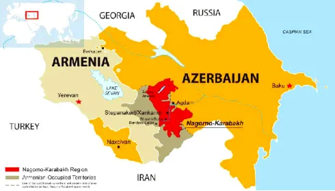
A year after tensions arising from Operation Sindoor, India and Azerbaijan have taken steps to restore and normalise bilateral relations. The 6th round of Foreign Office Consultations, held in Baku, marked the first such engagement since 2022, signaling renewed diplomatic momentum. Recent Diplomatic Engagement During the consultations, bo

India–Australia Economic Cooperation and Trade Agreem

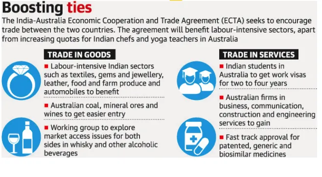
The India–Australia Economic Cooperation and Trade Agreement has completed four years since its signing. Both countries now aim to build on this progress through strengthened collaboration and ambitious targets, including reaching AUD 100 billion in bilateral trade by 2030. What is the India–Australia Economic Cooperation and Tra

ADR Report on Political Funding

A recent report by the Association for Democratic Reforms (ADR) analyses donations of ?20,000 or more declared to the Election Commission of India (ECI) by national political parties for FY 2024–25, highlighting transparency and accountability in political financing. Key Findings Massive Funding Surge Total donations to nationa

Maritime Chokepoints

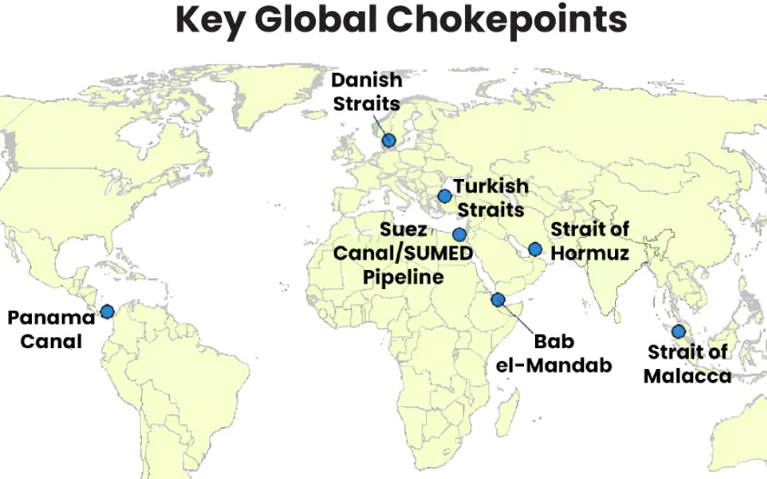
Maritime chokepoints are narrow channels along global shipping routes where maritime traffic is concentrated. These points are geopolitically and economically critical, as they handle a large proportion of global trade, especially energy shipments. Current Relevance Over two-thirds of seaborne energy trade passes through a handful o

US-Israel-Iran War

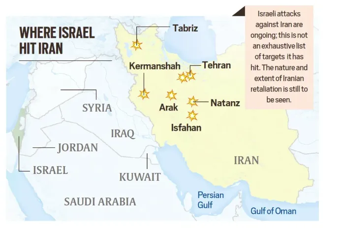
Following the launch of Operation Epic Fury (U.S.) and Operation Roaring Lion (Israel), the geopolitical landscape has shifted fundamentally with the confirmed death of Iran’s Supreme Leader, Ayatollah Ali Khamenei.Iran retaliated through Operation True Promise 4, launching missile attacks against Israel and nearby Gulf states. The escala

DNA

05 Apr,2026

Toppers

Search By Date

Newsletter Subscription
SMS Alerts

Important Links

UPSC GS Mains Crash Course - RAW